| | Thumbnail | | Creator | Date | Title / Author / Date / Location | Price | | | Description |
| 1228 | 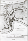 | Details | Poussin, Guillaume Tell | 1834 |
| Antique plan of New Orleans Louisiana ca. 1834 |
|
Poussin, Guillaume Tell |
|
| 1834 |
| LOC:0 |
| $0.00 | Poussin--Guillaume-Tell | Antique-plan-of-New-Orleans-Louisiana-ca--1834 | SOLD
<br></br>
Uncommon antique map or plan of New Orleans, Louisiana comprises the left half of the sheet. By William Tell Poussin (1796 - 1876), French architect, author, engineer, and diplomat.
<BR> </BR>
Detailed antique map of the New Orleans area shows the existing Carondolet Canal, Bienvenue Canal, and Treme Canal. The work also shows the proposed route of a canal to be constructed from the Mississippi River to Lake Ponchartrain running through the Faubourg Marigny along what is today Elysian Fields avenue. The canal was never constructed but in the 1830s the Ponchartrain Railway was built over the same route. The dream of a canal linking the lake with the river was not realized until 1923 with the opening of the Inner Harbor Navigation Canal (INHC), or "Industrial Canal".
<BR> </BR>
Includes a telling longitudinal elevation profile of the proposed canal from the Mississippi river to Lake Pontchartrain. Beginning at its highest point at the Mississippi River levee, the ground elevation along Elysian Fields Avenue declines gradually becoming "Forets inondees" until it crosses the Gentilly Ridge (an old natural levee) and the elevation increases.
<BR> </BR>
Right portion of the sheet contains a map of the Cheasapeake and Delaware Canal with a both a profile of the canal width and the canal length. Title on this half reads: "Plan de trace, situation des Ecluses, Nivellement general et Profile du Canal."
<BR> </BR>
Published in: "Travaux d'ameliorations interieures projetes ou executes par le Gouvernement General des Etats-Unis d'Amerique, de 1824 a 1831"; par Guillaume-Tell Poussin … Atlas. Paris, Anselin, Libraire, pour l'art militaire, les sciences et les arts, rue Dauphine, No. 36, dans le passage Dauphine. Carilian-Goeury, Libraire, des ponts et chaussees et des mines, Quai des Augustins, No. 41. 1834. Imprimerie de Lachevardiere, rue du Colombier, No. 30. |
| 1229 | 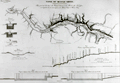 | Details | Poussin, Guillaume Tell | 1834 |
| Antique plan of the Tennessee River with Muscle Shoals Canal |
|
Poussin, Guillaume Tell |
|
| 1834 |
| LOC:0 |
| $0.00 | Poussin--Guillaume-Tell | Antique-plan-of-the-Tennessee-River-with-Muscle-Shoals-Canal | SOLD
<BR> </BR>
Antique plan of the Tennessee River and proposed canal in the vicinity of Muscle Shoals ca. 1834. By William Tell Poussin (1796 - 1876), French architect, author, engineer, and diplomat.
<BR> </BR>
Before the completion of the Wilson Dam in 1924, the Tennessee river was divided by a series of shoals near the Muscle Shoals area where the Tennessee fell over 100′ in approximately 30 miles. Between 1830 and 1890, adjacent to the river and around the shoals, a series of canals and locks were built and improved upon to provide for commercial navigation. This map captures some of the early planning for that work.
<BR> </BR>
Towns shown include Marathon, Tuscombia, Bainbridge, Havana, and Waterloo. Also depicts locations for Brown's Ferry, Lamb's Ferry, Furquhart's Ferry, and Florence Ferry. Other important topographical features include the Elk River, Melton's Bluff and the existing roads to Nashville, Columbus, and Huntsville. With a longitudinal cross section of the proposed canal
<BR> </BR>
Published in: "Travaux d'ameliorations interieures projetes ou executes par le Gouvernement General des Etats-Unis d'Amerique, de 1824 a 1831"; par Guillaume-Tell Poussin … Atlas. Paris, Anselin, Libraire, pour l'art militaire, les sciences et les arts, rue Dauphine, No. 36, dans le passage Dauphine. Carilian-Goeury, Libraire, des ponts et chaussees et des mines, Quai des Augustins, No. 41. 1834. Imprimerie de Lachevardiere, rue du Colombier, No. 30. |
| 1211 | 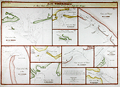 | Details | Poussin, Guillaume Tell | 1834 |
| Scarce French antique charts of Florida bays, anchorages and ports |
|
Poussin, Guillaume Tell |
|
| 1834 |
| LOC:61 |
| $0.00 | Poussin--Guillaume-Tell | Scarce-French-antique-charts-of-Florida-bays--anchorages-and-ports | SOLD
<br><br>
Ten very scarce antique nautical charts of Gulf Coast bays, passes, and port entrances from Mobile, Alabama past Apalachicola, Florida and the Ochlocknee River. An attractive copperplate-engraved French hydrographic composite chart printed in 1834 by French cartographer Guillaume Tell Poussin. Contains ten insets of north U.S. Gulf Coast ports in Alabama and Florida. These inset charts show soundings and isobaths (contour lines) in English feet. Text in French. Plate # 8. <BR> </BR>
Insets include the following areas: </BR>
Fig. 1. Entrée de la Baie de la Mobile (Entrance to Mobile Bay, Alabama with Dauphin Island and Fort Gaines to the west and Mobile Point with Fort Morgan on the east) </BR>
Fig. 2. Entrée de la Rade de Pensacole (Entrance to Pensacola Bay, Florida with Santa Rosa Island and Fort Pickens to the right. Also noted are Fort Barrancas and a Navy shipyard near Point Tartar) </BR>
Fig. 3. Entrée orientale du Detroit ou Canal de Santa Rosa (Entrance to Santa Rosa sound, Florida from the east side of Santa Rosa Island) </BR>
Fig. 4. Entrees du Detroit de St. Andre </BR>
Fig. 5. Entrée de la Baie ou Rade de St. Joseph </BR>
Fig. 6. Entrée principale du Detroit de St. Georges </BR>
Fig. 7. Entrée du milieu du Detroit de St. Georges </BR>
Fig. 8. Entrée orientale du Detroit de St. Georges </BR>
Fig. 9. Entrée de la Baie d'Appalachicola (Entrances to Apalachicola Bay, Florida and river) </BR>
Fig. 10. Entrée de la Baie d'Ocklockony (Entrance to Ochlocknee Bay, Florida)<BR> </BR>
After a chart by W.H. Swift from 1829.
<BR> </BR>
Published in: "Travaux d 'ameliorations interieures projetes ou executes par le Gouvernement General des Etats-Unis d 'Amerique, de 1824 a 1831"; par Guillaume-Tell Poussin … Atlas. Paris, Anselin, Libraire, pour l 'art militaire, les sciences et les arts, rue Dauphine, No. 36, dans le passage Dauphine. Carilian-Goeury, Libraire, des ponts et chaussees et des mines, Quai des Augustins, No. 41. 1834. |
| 1212 | 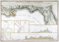 | Details | Poussin, Guillaume Tell | 1834 |
| Scarce French antique chart of the Florida Territory with proposed canals |
|
Poussin, Guillaume Tell |
|
| 1834 |
| LOC:0 |
| $0.00 | Poussin--Guillaume-Tell | Scarce-French-antique-chart-of-the-Florida-Territory-with-proposed-canals | SOLD <br></br>Beautiful antique chart of the United States Gulf Coast extending from the Atchafalaya River, past Bayou Lafourche and the Mississippi passes in Louisiana, Mobile Bay, Alabama, to the Florida east coast including most of what was then known as the Florida Territories (1822 - 1845). A scarce engraved French hydrographic chart by French cartographer Guillaume Tell Poussin from 1834.
<br></br>
<u>Insets include the following areas:</u> </BR>
Fig. 1. <b>Entrance to St. John's River.</b> "Entrée du Fleuve St. Jean". (Includes Fort George Island, Talbot Island and a feature noted as "General's Mount".)</BR>
Fig. 2. <b>Vicinity of Fernandina Beach and upper Amelia Island.</b> "Entrée de la Rade et de la Riviere St. Marie". </BR>
Fig. 3. <b>Plan of St. Augustine, Florida .</b> "Entrée orientale du Port St. Augustine". (Includes the Matanzas River and Anastasia Island.)
<BR> </BR>
Noted features include Lake Pontchartrain; New Orleans; Madisonville; Chandeleur Sound; Dauphin Island; Canal du Santa Rosa; Choctawhatchee Bay; Cape San Blas; Apalachicola Bay; Tallahassee; Cumberland Island; Tampa Bay; and Cape Canaveral. Includes boundaries and notations relating to the Seminole American Indian tribe. Dotted lines show the projected route of two proposed canals linking the Gulf and Atlantic coasts. Twin detailed elevation profiles at bottom are keyed alphabetically to the canal routes.
<BR> </BR>
Published in: "Travaux d 'ameliorations interieures projetes ou executes par le Gouvernement General des Etats-Unis d 'Amerique, de 1824 a 1831"; par Guillaume-Tell Poussin … Atlas. Paris, Anselin, Libraire, pour l 'art militaire, les sciences et les arts, rue Dauphine, No. 36, dans le passage Dauphine. Carilian-Goeury, Libraire, des ponts et chaussees et des mines, Quai des Augustins, No. 41. 1834. Text in French. Plate # 7. |
| 1213 | 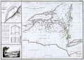 | Details | Poussin, Guillaume Tell | 1834 |
| Early plan of the Erie and Champlain Canals |
|
Poussin, Guillaume Tell |
|
| 1834 |
| LOC:53 |
| $350.00 | Poussin--Guillaume-Tell | Early-plan-of-the-Erie-and-Champlain-Canals | Very scarce original copperplate engraved of the Erie Canal (opened 1825) and the Champlain Canal by French engineer Guillaume Tell Poussin. Begun in 1817 and opened in its entirety in 1825, the Erie Canal is considered the engineering marvel of the 19th Century.
<br></br>
Engraved map. Relief shown by hachures. Includes profile of Erie Canal and Champlain Canal and view of covered bridge.
<br></br>
Plan du trace de Canal Erie et du Canal Champlain. Etat de New-York. // Plan du Port de Presqu'ile et du Barrage construit pour approfondir son entrée. // Détails de construction du pont de Mr. J. Town.
<br></br>
Published in: "Travaux d 'ameliorations interieures projetes ou executes par le Gouvernement General des Etats-Unis d 'Amerique, de 1824 a 1831"; par Guillaume-Tell Poussin … Atlas. Paris, Anselin, Libraire, pour l 'art militaire, les sciences et les arts, rue Dauphine, No. 36, dans le passage Dauphine. Carilian-Goeury, Libraire, des ponts et chaussees et des mines, Quai des Augustins, No. 41. 1834. Imprimerie de Lachevardiere, rue du Colombier, No. 30.<BR> </BR> |
| 405 | 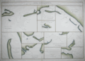 | Details | Poussin, Guillaume Tell | 1834 |
| Plans hydrographiques des baies, rades, ports et detroits des Florides |
|
Poussin, Guillaume Tell |
|
| 1834 |
| LOC:0 |
| $0.00 | Poussin--Guillaume-Tell | Plans-hydrographiques-des-baies--rades--ports-et-detroits-des-Florides | SOLD-
<a href="https://www.rarecharts.com/ShowDetail/Creator/Poussin--Guillaume-Tell/Title/Scarce-French-antique-charts-of-Florida-bays--anchorages-and-ports/1211" target="_blank">See a similar item in stock. </a>
<br></br>
Very scarce antique nautical chart of Gulf Coast bays, passes, and port entrances from Mobile, Alabama past Apalachicola, Florida and the Ochlocknee River. Unusual large copperplate engraved French hydrographic chart by French cartographer Guillaume Tell Poussin from 1834. Contains ten insets of north U.S. Gulf Coast ports in Alabama and Florida. These inset charts show soundings and isobaths (contour lines) in English feet. Text in French. Plate # 8. <BR> </BR>
Insets include the following areas: </BR>
Fig. 1. Entrée de la Baie de la Mobile (Entrance to Mobile Bay, Alabama with Dauphin Island and Fort Gaines to the west and Mobile Point with Fort Morgan on the east) </BR>
Fig. 2. Entrée de la Rade de Pensacole (Entrance to Pensacola Bay, Florida with Santa Rosa Island and Fort Pickens to the right. Also noted are Fort Barrancas and a Navy shipyard near Point Tartar) </BR>
Fig. 3. Entrée orientale du Detroit ou Canal de Santa Rosa (Entrance to Santa Rosa sound, Florida from the east side of Santa Rosa Island) </BR>
Fig. 4. Entrees du Detroit de St. Andre </BR>
Fig. 5. Entrée de la Baie ou Rade de St. Joseph </BR>
Fig. 6. Entrée principale du Detroit de St. Georges </BR>
Fig. 7. Entrée du milieu du Detroit de St. Georges </BR>
Fig. 8. Entrée orientale du Detroit de St. Georges </BR>
Fig. 9. Entrée de la Baie d'Appalachicola (Entrances to Apalachicola Bay, Florida and river) </BR>
Fig. 10. Entrée de la Baie d'Ocklockony (Entrance to Ochlocknee Bay, Florida)<BR> </BR>
Published in: "Travaux d 'ameliorations interieures projetes ou executes par le Gouvernement General des Etats-Unis d 'Amerique, de 1824 a 1831"; par Guillaume-Tell Poussin. |