| | Thumbnail | | Creator | Date | Title / Author / Date / Location | Price | | | Description |
| 8079 | 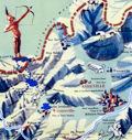 | Details | Sink, John | 1948 |
| Scarce pictorial map of western North Carolina |
|
Sink, John |
|
| 1948 |
| LOC:41 |
| $450.00 | Sink--John | Scarce-pictorial-map-of-western-North-Carolina | Western North Carolina: a vacationist's map and guide is a colorful mid-20th century pictorial map ca. 1948 illustrated by John Sink, a commercial artist known for lively regional tourist imagery. The map presents the Blue Ridge and Great Smoky Mountains as a continuous mountain chain extending from the Tennessee line eastward across western North Carolina ending at the Sauratown Mountains with Hanging Rock State Park.<br><br>
Peaks, gaps, and valleys are shown in bold, sculptural relief, while towns such as Asheville, Boone, and Bryson City anchor the geography. Cartoon figures hiking, skiing, fishing, and sightseeing animate the landscape, emphasizing recreation and leisure ("The Fun") rather than precise navigation.<br><br>
Designed as both a guide and a promotional image, the map combines expressive illustration with practical travel information. Major highways and scenic routes, including the Blue Ridge Parkway, trace the mountain ridges, while airplanes, automobiles, and roadside signage reflect the postwar rise of leisure travel by car and air. An inset conventional road map ("The Hiways") at lower right shows a detailed network of highways serving western North Carolina, reinforcing the sheet's function as both a souvenir image and a usable tourist guide.
<br><br>Text on verso with twelve proposed routes for scenic tours throughout the region. |
| 6695 |  | Details | Sink, John | 1949 |
| Pictorial Map Eastern North Carolina Vacationist's Guide Sink |
|
Sink, John |
|
| 1949 |
| LOC: |
| $0.00 | Sink--John | Pictorial-Map-Eastern-North-Carolina-Vacationist-s-Guide-Sink | SOLD<br><br>Rare and nicely lithographed folding pictorial map "Eastern North Carolina Vacationist's Guide" by John Sink ca. 1949. Also, Sink is credited with a similar map: "Western North Carolina and vacationists map and guide."
<br><br>
WorldCat records only five institutional holdings of this map.
<br><br>
Very interesting pictorial map. On the verso the description of some of the coast's less well-travelled areas is priceless.
<br>
<div class="indenttextblocksingle">
"Down the Outer Banks of North Carolina, from junction of road with US 158 to Hatteras. 60 miles. This tour is recommended for the adventurous and only the <b>good sand driver</b> should attempt it in his own car. Much of the route is without benefits of highways, and often the inexpert driver is <b>stalled in the sand.</b> Generally, best driving is on the beach at low tide (it should not be attempted on an incoming tide). All the villages are on the Sound side, however, and to reach them, motorists must drive across the top of the beach, usually through soft sand. Take a can of extra water... There are coast guard stations along the way where help may be obtained. There are no facilities or dwellings between villages."
<br><br>
" ... junction of a paved road (L) with US 158 at the so-called Whalebone site. Turn left on this road which is paved for only a mile, and down either the "inside" set of sand ruts or the beach. The route runs along an undeveloped beach section, with here and there the remains of old wrecks. At 05.0 on R is Bodie Island (pronounced body) lighthouse. It first was erected in 1848, rebuilt in 1859 and destroyed during the Civil War. While the present tower was under construction five sailing vessels were wrecked on the beach. Rebuilt in 1872, the structure is 162 feet high, has a 160,000 candlepower beam visible 19 m. "
</div>
<br> |