| | Thumbnail | | Creator | Date | Title / Author / Date / Location | Price | | | Description |
| 5277 | 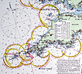 | Details | Stanford, Edward | 1900 |
| Superb late 19th-century nautical chart of the English Channel |
|
Stanford, Edward |
|
| 1900 |
| LOC:1409 |
| $2,575.00 | Stanford--Edward | Superb-late-19th-century-nautical-chart-of-the-English-Channel | A visually captivating and informative original antique 19th-century nautical reference chart of the English Channel with visible extent of lighthouses shown graphically. Uncommon. The few similar items that come to mind are Hardinge's 1874 "British Lighthouse Chart of General Coast Lights", and "A Chart Exhibiting the Light Houses and Light Vessels of the Coasts of Great Britain and Ireland" issued by the Corporation of the Trinity House, 1863.
<br><br>
This antique original, rolled, linen-backed chart, based on data from Lieutenant H.C. Lockyer in 1899, was published by Edward Stanford from Stanford's Geographical Establishment in London on March 1, 1900. Stanford's, established in 1853, remains in business today, now at 7 Mercer Walk in Covent Garden.
<br></br>
Coverage includes relevant portions of the coast of Ireland, Wales, England, and France, with Cornwall near chart center.
<br><br>
Scarce, especially in fine condition as this example. Only one institutional holding in WorldCat.
<br></br>
Contains drawings of the uniform system of buoyage: starboard-hand buoys, port-hand buoys, middle ground buoys; pillar, spar, and gas buoys; and wreck-marking vessels. Of great visual interest are the dozens of lighthouses identified on the chart with the range, frequency, duration, and color of each light provided for navigators. The chart is filled with tide tables, general information, soundings and distances and sailing directions for numerous ports. Topographical detail useful to navigators is shown for coastal locations and for those inland locations where the height of a feature warranted inclusion, e.g. Brecknock Mountain, Wales at 2862 ft. elevation.
<br></br> |
| 715 | 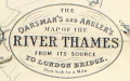 | Details | Stanford, Edward | 1901 |
| Oarsman's and Anglers Map of the River Thames from its Source to London Bridge |
|
Stanford, Edward |
|
| 1901 |
| LOC:0 |
| $425.00 | Stanford--Edward | Oarsman-s-and-Anglers-Map-of-the-River-Thames-from-its-Source-to-London-Bridge | <BR></br><div class="indenttextblock">"The Editors… have endeavored to lay down the course over which a punt should be shoved. <i>They wish it to be distinctly understood that they do not claim to have found the best shoving in all cases</i>, but they have tried to describe the bottom of the river as they know it, perhaps not as intelligibly as they would have wished, owing to the exigencies of space and the subsequent condensation of language. "</div>
<br>Thus begins the introduction to this very interesting and quirky map of the Thames River, published in 1901 and oriented to the fishermen and boaters of the area. Filled with information about the Thames, not only locks, water depth, bridges and other navigational information, but also, inns, hotels, and boatyards.
<br></br>
A reader does not have to go too far perusing the notes on this chart to need a good nautical reference book, as some of the practices of that era are now outdated or not applicable in other countries. For example this note on Hart's or Eaton's Weir: <div class="indenttextblock">"The only weir on the Thames which has to be 'shot'. There is usually someone at the neighboring inn who will lend a hand in drawing the paddles and rymers." </div> Hmmm. Turns out that the term "paddles and rymers" refers to a method of lock construction for "flash locks" based on a single gate. The method of construction dates back to the medieval period. Paddle and rymer weirs are operated by placing large wooden posts – the rymers – into the bottom of the river. To control the water flow, paddles of different heights were placed against the rymers. When the paddles were removed water would pour through the opening and boaters would "shoot" the opening. This method of construction is now considered dangerous and most paddle and rymer weirs have been updated.
<br></br> Published by Edward Stanton, 12, 13, & 14, Long Acre, W.C. |
| 995 | 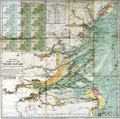 | Details | Stanford, Edward | 1920 |
| Stanford's Colored Chart of the Thames Estuary |
|
Stanford, Edward |
|
| 1920 |
| LOC:0 |
| $145.00 | Stanford--Edward | Stanford-s-Colored-Chart-of-the-Thames-Estuary | 2 coloured lithographic charts mounted on linen and folding into the same original cloth covers with paper label. With a tide table and 12 small inset maps showing tidal flows in knots over a 12 hour period based on high-water at Dover.
<br></br>
Two folding charts, the largest mounted on linen and both folding into the same original cloth covers with paper label.
<br/>
--Estuary Chart "Stanford's Chart of the Thames Estuary Prepared Under the Supervision of Captain O.M. Watts, A.I.N.A.". 28" x 27".
<br/>
--River Thames. "The River Thames from London to Gravesend". 20" x 6"
<br></br>
Original blue cloth boards with mounted printed publisher's plate to front cover. Published by Edward Stanton, 12, 13, & 14, Long Acre, W.C.2 London and Whitehall S.W.1 |