| | Thumbnail | | Creator | Date | Title / Author / Date / Location | Price | | | Description |
| 1393 | 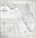 | Details | U.S. War Department | 1846 |
| First Map of the State of Florida |
|
U.S. War Department |
|
| 1846 |
| LOC:0 |
| $0.00 | U-S--War-Department | First-Map-of-the-State-of-Florida | SOLD <br></br>
A very large (40" x 42"), comprehensive, original map of Florida that was published in 1846<b>, one year after Florida gained statehood</b>. An important, and informative map of Florida, one of the first produced after Florida’s admission to the Union on March 3, 1845, carrying much useful military information particularly regarding the <b>Seminole tribe</b>.
<br></br>
This antique map exhibits great detail and precision, especially in the coastline, and gives much information on the physical and cultural geography of the state. Numerous forts and military camps are located. The surveys extend along the coast south of Cape Canaveral, with the majority of the southern interior portion of the state still unsurveyed.
<br></br>
The Florida Everglades are identified along with a notation regarding the land assigned to native Americans: "District assigned to the Seminoles by the arrangement of Gen.' Macomb May 18th 1839." Three large inset maps fill the Gulf of Mexico: "Key West as surveyed February 1829"; "Mouths of Swanee R. and Cedar Keys showing the Western terminus of a proposed railroad"; and "A General Map of part of Florida included between Cedar Keys and St. John's River."
<br></br>
The map was drawn by Joseph Goldsborough Bruff and finely engraved by D. McClelland of the Topographical Engineers. Bruff was a draftsman and cartographer who served as a mapmaker for the Bureau of Topographical Engineers. The Library of Congress notes: <div class="indenttextblock">" … J. Goldsbourough Bruff, was a native of Washington, D.C. At an early age he was admitted to West Point, but after only two years he was forced to leave the prestigious military academy after participating in a duel. He later became a professional cartographer and draftsman, as well as an amateur artist and adventurer. <a href="http://www.loc.gov/exhibits/mapping-a-growing-nation/online-exhibition.html#obj017" target="_blank"> (Internet). </a></div> |
| 4947 | 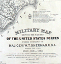 | Details | U.S. War Department | 1865 |
| Military Map Marches of General Sherman Forces |
|
U.S. War Department |
|
| 1865 |
| LOC:53 |
| $850.00 | U-S--War-Department | Military-Map-Marches-of-General-Sherman-Forces | Fine original lithographed map showing the marches of the United States Forces under command of Major General W.T. Sherman U.S.A. during the years 1863, 1864, 1865.
<br></br>
Drawn by Captain William Kossak in St. Louis MO and printed by the American Photo Lithographic Company of New York using "Osborne's process." [1] The map was compiled by order of General Sherman under the direction of Brevet. Major W.L.B. Jenney. It covers the region bounded by Mobile in the south, Washington and St. Louis in the north, Chesapeake Bay to the east and to the west by Little Rock, Arkansas.
<br></br>
[1] Osborne's process was a photo-lithographic process based on a large copy camera and photo-sensitized transfer paper made from photo negatives. By 1866 the American Photolithographic Company operated a massive copy camera with a 14 foot platform at its Brooklyn plant. The huge apparatus was capable of reproducing drawings up to forty-eight by sixty inches. (Reps, John William. Views and View makers of Urban America: Lithographs of Towns and Cities in the United States … University of Missouri Press. 1984. pp 36, 37.) |
| 1333 |  | Details | U.S. War Department | 1934 |
| Old War Department Map of New Orleans Area 1934 |
|
U.S. War Department |
|
| 1934 |
| LOC:1401 |
| $450.00 | U-S--War-Department | Old-War-Department-Map-of-New-Orleans-Area-1934 | Large, original War Department / U.S. Corps of Engineers blueprint index map from 1934 for south-eastern Louisiana including New Orleans, Donaldsonville, Baton Rouge, Mandeville, Slidell and Bay St. Louis. Names railways, numerous waterways and bodies of water, but does not show roads or highways. Includes the Bonnet Carre Floodway (completed 1931), the Harvey Locks, portions of the Intracoastal Canal (later called the Gulf Intracoastal Waterway or ICWW), Lake Borgne, Lake Ponchartrain, Barataria Bay, Atchafalaya Bay, and the Mississippi River as far south as Venice, Louisiana. Perfect for the man cave.
<br></br>
On this map the route shown for the Intracoastal Canal passes through Lockport, Louisiana and Bayou Terrebonne. The segment of the canal from Larose to Bourg, Louisiana to was not completed until 1949.
<br></br>
Dated within at bottom right to 1934. Drawn by L. Lecaze. |