| | Thumbnail | | Creator | Date | Title / Author / Date / Location | Price | | | Description |
| 6455 | 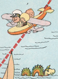 | Details | White, Ruth Taylor | 1929 |
| Six early pictorial airline route maps by Ruth Taylor White |
|
White, Ruth Taylor |
|
| 1929 |
| LOC:14 |
| $1,200.00 | White--Ruth-Taylor | Six-early-pictorial-airline-route-maps-by-Ruth-Taylor-White | Rare and fine eleven-page brochure for Western Air Express published in 1929, just three and one-half years after the airline was founded. Includes six pictorial airline route maps or cartographs by famed illustrator Ruth Taylor White. </b> Maps with inset half-tone images of aircraft and flight operations.
<br><br>
The Western Air Express Corporation, later Western Airlines, began its first passenger service in 1926 touting speed, comfort, and dependability. By 1928, employing Fokker Super Tri-motor passenger aircraft capable of transporting twelve passengers at a blistering 125 MPH, the airline "carried about eighteen percent of all inter-city passengers in the United States." In 1928 the company initiated a seaplane route from Catalina Island, California to Los Angeles, California. Maps include:
<div class="indenttextblocksingle">
<ul style="list-style-type: circle;"></li>
<li><b>San Francisco - Los Angeles.</b> 365 miles, 3 hours. "The Worlds Model Air Line." Two facing sheets, each 7.5" x 8"</li>
<li><b>Los Angeles - Kansas City.</b> 1,417 miles - 12 hours. First and fastest all Daylight Passenger Airway." Two facing sheets each 7.5" x 8".</li>
<li><b>Los Angeles to Catalina.</b> 45 miles - 30 minutes. "Over land and sea. The first air passenger service in the United States. Single center-fold sheet 15" x 8".<br>
<b> Los Angeles to Tia Juana or Agua Caliente".</b> 116 miles - 1 hour. With above. </li>
<li><b>Los Angeles - Salt Lake City.</b> 600 miles - 6 hours. "Over the Old Mormon Trail". Two facing sheets each 7.5" x 8".</li>
<li>Map of the USA showing expected travel-time zones, indicated by color legend. No title. One half sheet.</li>
<li>B&W inset map showing location of the Western Air Express Terminal south of San Gabriel. No title.</li>
<li>Cover 8" x 9" showing all included passenger routes for Western Air Express.</li>
</ul>
</div>
Publication date noted within as October, 1929. Folds down to 4" x 9". |
| 6540 | 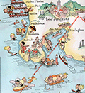 | Details | White, Ruth Taylor | 1929 |
| Pictorial Western Air Express route map by Ruth Taylor White |
|
White, Ruth Taylor |
|
| 1929 |
| LOC:78 |
| $135.00 | White--Ruth-Taylor | Pictorial-Western-Air-Express-route-map-by-Ruth-Taylor-White | Pictorial airline route map or cartograph by famed illustrator Ruth Taylor White for Western Air Express published in 1929, just three and one-half years after the airline was founded. Inset half-tone images of an early seaplane and of Avalon Harbor on Catalina. <br><br>
<div id="1" align="center">
<a title="Western Air Express 1929 Seaplane"></a>
<img id="1" src="/ZoomifyImages/SC_6540/SC_6540_Seaplane.jpg" alt="Western Air Express 1929 Seaplane" width="300"/> <br><small>Western Air Express 1929 Seaplane, LA to Catalina</small>
</div><br>
This map include two routes flown from Los Angeles by Western Air Express:
<div class="indenttextblocksingle">
<ul style="list-style-type: circle;"></li>
<li><b>Los Angeles to Catalina.</b> 45 miles - 30 minutes. "Over land and sea. The first air passenger service in the United States.<br>
<b> Los Angeles to Tia Juana or Agua Caliente".</b> 116 miles - 1 hour.</li>
</div>
<div id="2" align="center">
<a title="Ruth Taylor White LA to Catalina route map details"></a>
<img id="2" src="/ZoomifyImages/SC_6540/SC_6540_Detail.jpg" alt="Ruth White map details" width="300"/> <br><small>Ruth Taylor White LA to Catalina route map detail</small>
</div><br>
The Western Air Express Corporation, later Western Airlines, began its first passenger service in 1926 touting speed, comfort, and dependability. By 1928, employing Fokker Super Tri-motor passenger aircraft capable of transporting twelve passengers at a blistering 125 MPH, the airline "carried about eighteen percent of all inter-city passengers in the United States." In 1928 the company initiated a seaplane route from Catalina Island, California to Los Angeles, California. Publication date: October, 1929. |
| 6643 | 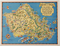 | Details | White, Ruth Taylor | 1931 |
| Pictorial map of the Island of Oahu in Hawaii |
|
White, Ruth Taylor |
|
| 1931 |
| LOC:89 |
| $200.00 | White--Ruth-Taylor | Pictorial-map-of-the-Island-of-Oahu-in-Hawaii | Fine lithographed cartograph or pictorial map of the island of Oahu, Hawaii by Ruth Taylor White. In 1931 White produced four maps of individual islands for the Hawaii Tourist Bureau: Kauai, Maui, Hawaii, Oahu, and one map of the entire Hawaiian Island chain. Printed by the Honolulu Star-Bulletin.
<br><br>
Locations and features that White captured on her map of Oahu include:"
<div class="indenttextblocksingle">
<ul style="list-style-type: circle;"></li>
<li>Waimea Falls</li>
<li>Kaneohe Bay</li>
<li>Kailua Bay</li>
<li>Diamond Head</li>
<li>Waikiki Beach</li>
<li>Honolulu</li>
<li>Pearl Harbor</li>
<li>Koko Head</li>
</ul>
</div> |
| 6644 |  | Details | White, Ruth Taylor | 1931 |
| Pictorial map of the island of Maui in Hawaii |
|
White, Ruth Taylor |
|
| 1931 |
| LOC:89 |
| $250.00 | White--Ruth-Taylor | Pictorial-map-of-the-island-of-Maui-in-Hawaii | Fine lithographed cartograph or pictorial map of the island of Maui, Hawaii by Ruth Taylor White. In 1931 White produced four maps of individual islands for the Hawaii Tourist Bureau: Kauai, Maui, Hawaii, Oahu, and one map of the entire Hawaiian Island chain. Printed by the Honolulu Star-Bulletin.
<br><br>
Locations and activities that White featured on her map of Maui include:"
<div class="indenttextblocksingle">
<ul style="list-style-type: circle;"></li>
<li>Lahaina</li>
<li>Kaanapali</li>
<li>Kahului Harbor</li>
<li>Hana</li>
<li>Kipahuhu</li>
<li>Molokini</li>
<li>Makena</li>
<li>Wailuku</li>
</ul>
</div> |
| 6645 | 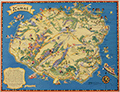 | Details | White, Ruth Taylor | 1931 |
| Pictorial map of the island of Kauai in Hawaii Polynesia |
|
White, Ruth Taylor |
|
| 1931 |
| LOC:89 |
| $250.00 | White--Ruth-Taylor | Pictorial-map-of-the-island-of-Kauai-in-Hawaii-Polynesia | Fine lithographed cartograph or pictorial map of the Polynesian island of Kauai, Hawaii by Ruth Taylor White. In 1931 White produced four maps of individual islands for the Hawaii Tourist Bureau: Kauai, Maui, Hawaii, Oahu, and one map of the entire Hawaiian Island chain. Printed by the Honolulu Star-Bulletin.
<br><br>
Locations and activities that White featured in her map of the Island of Kauai include:"
<div class="indenttextblocksingle">
<ul style="list-style-type: circle;"></li>
<li>Barking Sands</li>
<li>Napali Coast</li>
<li>Hanalei Beach</li>
<li>Moloaa</li>
<li>Nawiliwili Harbor</li>
<li>Port Allen</li>
<li>Ruins of Russian Port</li>
<li>Waimea</li>
</ul>
</div> |
| 6646 | 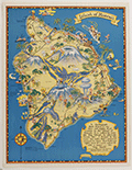 | Details | White, Ruth Taylor | 1931 |
| Pictorial map of the Island of Hawaii |
|
White, Ruth Taylor |
|
| 1931 |
| LOC:89 |
| $200.00 | White--Ruth-Taylor | Pictorial-map-of-the-Island-of-Hawaii | Fine lithographed cartograph or pictorial map of the island of Hawaii by Ruth Taylor White. In 1931 White produced four maps of individual islands for the Hawaii Tourist Bureau: Kauai, Maui, Hawaii, Oahu, and one map of the entire Hawaiian Island chain. Printed by the Honolulu Star-Bulletin.
<br><br>
Locations and features that White featured in her map of Hawaii include:"
<div class="indenttextblocksingle">
<ul style="list-style-type: circle;"></li>
<li>Mauna Kea</li>
<li>Mauna Loa</li>
<li>Kilauea</li>
<li>Hilo</li>
<li>Kealakekua Bay</li>
<li>Kailua</li>
<li>Upolu Point</li>
<li>Hookena</li>
<li>Hoopuloa</li>
</ul>
</div> |
| 6471 | 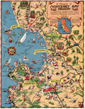 | Details | White, Ruth Taylor | 1932 |
| Ruth Taylor 1932 pictorial map cartograph Monterey Bay Region |
|
White, Ruth Taylor |
|
| 1932 |
| LOC:78 |
| $0.00 | White--Ruth-Taylor | Ruth-Taylor-1932-pictorial-map-cartograph-Monterey-Bay-Region | SOLD<br><br>Fine original pictorial map or cartograph of the Monterey Bay Region by Ruth Taylor (1932). Later Ruth would sign her many maps with her married name, Ruth Taylor White. The map represents some of Ruth's earliest work, just three years after she drew four beautiful route-map cartographs for Western Air Express' newly inaugurated passenger service (1929). First edition, lacking the black redaction of the 2nd edition.
<br><br>
<div id="0" align="center">
<a title="Ruth Taylor White 1929 cartograph for Western Air Express"></a>
<img id="3" src="/ZoomifyImages/SC_6455/SC_6455_CaliRoutes.jpg" alt="Ruth Taylor White 1929 cartograph for Western Air Express" width="330"/> <br><small>Ruth Taylor White 1929 cartograph for Western Air Express.</small>
</div><br>
The cartograph was probably published by the Chamber of Commerce of the Pajaro Valley as the verso text promoting Watsonville, California refers to the map on the recto as "the marvelously scenic Monterrey Bay Region (pictured on the reverse side.)" |
| 2547 | 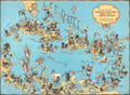 | Details | White, Ruth Taylor | 1935 |
| Amusing Pictorial Map of the Caribbean Islands |
|
White, Ruth Taylor |
|
| 1935 |
| LOC:88 |
| $0.00 | White--Ruth-Taylor | Amusing-Pictorial-Map-of-the-Caribbean-Islands | SOLD
<br></br>
Decorative, playful map of the Caribbean Islands by Ruth Taylor White. Coverage includes south Florida, Cuba, the Bahamas, the Windward and Leeward Islands, Central America, and portions of Colombia and Venezuela. The Caribbean Islands are shown in a cartoon-like style complete with palm trees, flamingos, cruise ships and numerous stylized native inhabitants in local costumes. At the Panama Canal Zone a United States soldier stands guard with gun at shoulder. Page 85. |