| | Thumbnail | | Creator | Date | Title / Author / Date / Location | Price | | | Description |
| 1043 |  | Details | de Fer, Nicolas | 1690 |
| Title Page for Les Costes de France |
|
de Fer, Nicolas |
|
| 1690 |
| LOC:1 |
| $120.00 | de-Fer--Nicolas | Title-Page-for-Les-Costes-de-France | Very cool and interesting title page with a depiction of numerous late 17th century maritime activities attending harbor work.
<br></br>
This title page was produced by the well known French geographer and cartographer, Nicolas de Fer (1646 - 1720). De Fer was a prolific producer of maps and prints who among other honors, was appointed as official geographer to the Spanish King in 1702. Published in de Fer's atlas: "Les Costes de France sur l'Océan et la Mer Mediterranee..." with 32 engraved charts. That work was a re-issue of Christophe Tassin's 1634 work "Cartes Generale et Particulieres de toutes le costes de France tant de la mer Oceane que Mediterranee". |
| 1434 | 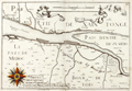 | Details | de Fer, Nicolas | 1690 |
| Scarce French chart of Medoc Bordeaux wine region |
|
de Fer, Nicolas |
|
| 1690 |
| LOC:7 |
| $450.00 | de-Fer--Nicolas | Scarce-French-chart-of-Medoc-Bordeaux-wine-region | For the lover of <b>Bordeaux wines</b>, this fine antique French map encompasses the Bordeaux wine region along France's Gironde, Garonne and Dordogne Rivers. Our 17th-century coastal map is Nicolas de Fer's re-issue of N. Tassin's original engraved map / chart (ca. 1640) of the area. Landmarks of the Bordeaux region noted on the map include le Pays de Medoc, Partie de Xaintonge, Margos (Margaux), Macan, Saint-Julien, Petit Bordeaux, S. Estienne (Saint-Estephe ?), Bourg de Blaye, Pauilliac, Listra (Listrac-Medoc ?). Number 23.
<br></br>
Originally published circa 1640 by N. Tassin whose engravings are of special interest as the first French atlas to focus solely on France's coastal margins. Tassin has a distinctive style characterized by his use of images of numerous sailing vessels, and his large, elaborate compass roses.
<br></br>
This map was produced with royal privilege by the well known French geographer and cartographer, Nicolas de Fer (1646 - 1720). De Fer was a prolific producer of maps and prints who among other honors, was appointed as official geographer to the Spanish King in 1702.
<br></br>
de Fer bought rights to Tassin's atlas- "Cartes Generale et Particulieres de toutes le costes de France" added his imprint and title page, and re-issued the work. Published in de Fer's atlas: "Les Costes de France sur l'Océan et la Mer Mediterranee..." with 32 engraved charts. That work was a re-issue of Christophe Tassin's 1634 work "Cartes Generale et Particulieres de toutes le costes de France tant de la mer Oceane que Mediterranee". |
| 1425 | 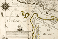 | Details | de Fer, Nicolas | 1690 |
| Scarce French chart of Bordeaux region with Pauilliac Grand-Cru |
|
de Fer, Nicolas |
|
| 1690 |
| LOC:7 |
| $500.00 | de-Fer--Nicolas | Scarce-French-chart-of-Bordeaux-region-with-Pauilliac-Grand-Cru | For the lover of Bordeaux wines, this fine antique French map encompasses the northwestern Bordeaux region of France including the area now occupied with the village of Pauilliac and three of the Grand-Crus vineyards of Bordeaux: Lafite-Rothschild, Mouton-Rothschild, and Latour. Our 17th-century coastal map is Nicolas de Fer's re-issue of N. Tassin's original engraved map / chart (ca. 1640) of the Gironde River mouth. Other landmarks of the Bordeaux region (not drawn anywhere close to scale) include Coste de Medoc (appellee Coste Sauvage) , I. Cordouan, Royan, Soulac-sur-Mer, Carcans, and Lacanau. Number 22.
<br></br>
Checking Google Maps along the estuary of the Gironde River we find an area of the left bank with several river outlets opposite large islands. The major town is not Tassin's or de Fer's "Palus" but Pauilliac.
<br></br>
Originally published circa 1640 by N. Tassin whose engravings are of special interest as the first French atlas to focus solely on France's coastal margins. Tassin has a special style characterized by his use of images of numerous sailing vessels, and his large, elaborate compass roses.
<br></br>
This map was produced with royal privilege by the well known French geographer and cartographer, Nicolas de Fer (1646 - 1720). De Fer was a prolific producer of maps and prints who among other honors, was appointed as official geographer to the Spanish King in 1702.
<br></br>
de Fer bought rights to Tassin's atlas- "Cartes Generale et Particulieres de toutes le costes de France" added his imprint and title page, and re-issued the work. Published in de Fer's atlas: "Les Costes de France sur l'Océan et la Mer Mediterranee..." with 32 engraved charts. That work was a re-issue of Christophe Tassin's 1634 work "Cartes Generale et Particulieres de toutes le costes de France tant de la mer Oceane que Mediterranee". |
| 792 | 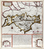 | Details | de Fer, Nicolas | 1692 |
| Isle of Wight, Solent, and South England |
|
de Fer, Nicolas |
|
| 1692 |
| LOC:89 |
| $400.00 | de-Fer--Nicolas | Isle-of-Wight--Solent--and-South-England | Antique nautical chart of the Isle of Wight, the Solent, and part of the south coast of Great Britain by French cartographer Nicolas de Fer. Published in 1692. Noted features of this attractive, colorful sea-chart include: Parkhurst Forest ("Wachinu Park"), the Golfe de Southampton, Pointe de Rames-head, Harve de Hamble, Harve de Rey, Presqu' Isle de Freshwater, Presque Isle de Binbridge, Banc de Mackett, and Spithead. Habitations shown include: Tirchfeild, Newchurch, Portsmouth, Gosport, Worth, Yarmouth, Newport, Helene, Nordwood, Yaverland, and St. Laurens Park. Two insets at bottom depict Tor Baye, and the Scilly Islands ("Isles Solrlingues").
<br></br>
The title cartouche carries the attribution: " A Paris Chez N. de Fer dans l'ile du Palais sur le Quaye de 'lOrloge a la Sphere Royale, aver Priv du Roy, 1692". Published from Paris, France by French geographer and cartographer, Nicolas de Fer (1646 - 1720). De Fer was a prolific producer of maps and prints who among other honors, was appointed as official geographer to the Spanish King in 1702. |
| 998 | 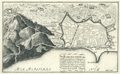 | Details | de Fer, Nicolas | 1693 |
| Old plan of Barcelona, Spain |
|
de Fer, Nicolas |
|
| 1693 |
| LOC:4 |
| $495.00 | de-Fer--Nicolas | Old-plan-of-Barcelona--Spain | Attractive, detailed antique birds-eye view or plan of Barcelona, Spain on the Mediterranean Sea, from 1693. Will frame and display nicely.
<br></br>
This antique copperplate-engraved map was produced toward the end of the 17th century by the well known French geographer and cartographer, Nicolas de Fer (1646 - 1720). De Fer was a prolific producer of maps and prints who among other honors, was appointed as official geographer to the Spansh King in 1702. From de Fer's "Forces de l'Europe ou Introduction a la Fortification". |
| 720 | 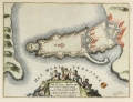 | Details | de Fer, Nicolas | 1693 |
| Syracuse or Siracuse, Sicily |
|
de Fer, Nicolas |
|
| 1693 |
| LOC:4 |
| $0.00 | de-Fer--Nicolas | Syracuse-or-Siracuse--Sicily | SOLD<br><br>
Beautiful antique plan of the fortifications at Syracuse ( Siracuse ) on the Mediterranean island of Sicily. Title cartouche at bottom surrounded by putti engaged in agricultural and food gathering activities. Text in French describes the location precisely with Latitude and Longitude. By Nicolas de Fer, in "Introduction à la fortification." Paris 1693. |
| 297 | 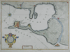 | Details | de Fer, Nicolas | 1700 |
| Isle Ville et Port de Cadis |
|
de Fer, Nicolas |
|
| 1700 |
| LOC:4 |
| $225.00 | de-Fer--Nicolas | Isle-Ville-et-Port-de-Cadis | Scarce antique map of the bay and island of Cadiz, Spain from ca. 1696 - 1708. This neat copperplate engraving is oriented to the north and shows some details of the city and port of Cadis including Pont. St Sebastien, Pte. Caterine, and Caleta. A single bridge is shown at the north end of the island : Pont de Suaco. Other habitations noted are Rota, (Rotta) Port Saint Marie, Port Real, Chiclana, Puntal, and Isle St. Pierre. Most of the island is shown covered by agricultural fields, apparently vineyards, labeled with rare praise (for a Frenchman) "ou croit le meilleur vin d'Espagne" translated very roughly as- 'thought to be the best Spanish wine'.<BR> </BR>
This antique map was produced toward the end of the 17th century by the well known French geographer and cartographer, Nicolas de Fer (1646 - 1720). De Fer was a prolific producer of maps and prints who among other honors, was appointed as official geographer to the Spanish King in 1702. |
| 300 | 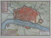 | Details | de Fer, Nicolas | 1700 |
| Anvers |
|
de Fer, Nicolas |
|
| 1700 |
| LOC:7 |
| $350.00 | de-Fer--Nicolas | Anvers | Small antique map /plan of the historic town of Antwerp (Anvers), Belgium ca. 1700. Shows the walled and moated city of Antwerp along the Scheldt (Escaut) river with an additional fortress ( Citadelle ) attached on the upstream end of the city. A general street plan is supported by a 20+ item legend identifying key points in the city and surrounding area.<BR> </BR>
This antique copperplate-engraved map was produced toward the end of the 17th century by the well known French geographer and cartographer, Nicolas de Fer (1646 - 1720). De Fer was a prolific producer of maps and prints who among other honors, was appointed as official geographer to the Spansh King in 1702. |
| 879 | 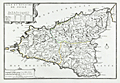 | Details | de Fer, Nicolas | 1701 |
| Antique Map of the Mediterranean island of Sicily, Italy |
|
de Fer, Nicolas |
|
| 1701 |
| LOC:4 |
| $240.00 | de-Fer--Nicolas | Antique-Map-of-the-Mediterranean-island-of-Sicily--Italy | Attractive antique map of the island of <b>Sicily</b> in Italy published from Paris in 1701 . Adjoining the mainland at the "toe" of the Italian peninsula, and separated by the Strait of Messina, the southernmost tip of Calabria is shown with the key city of Reggio.
<br></br>
Much detail in the interior of this original old map includes mountains, rivers, major roads, and villages. Key cities in Sicily include Palermo, Messina, Noto, Mazara, and Siracusa. A few miles northwest of the coastal city of Catania, <b>Mount Etna</b> ( Aetna ) is shown erupting violently.
<br></br>
At the time this map was published Sicily, the largest of all Mediterranean islands, was ruled by Philip IV , King of Spain.
<br></br>
This antique map was produced by the well known French geographer and cartographer, Nicolas de Fer (1646 - 1720) and was published in de Fer's atlas: "L'atlas curieux, ou Le monde réprésenté dans des cartes générales et particulières du ciel et de la terre… et orné par des plans et descriptions des villes capitales et principales ..."
<br></br>
Publication details are found In the lower left corner : <div class="indenttextblock">" A Paris. Chez l'Autheur dans l'Isle du Palais a la Sphere Royale. Avec Privilege du Roy. 1701. " </div> |
| 880 | 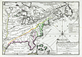 | Details | de Fer, Nicolas | 1702 |
| Nicolas de Fer's Map of Canada and New France |
|
de Fer, Nicolas |
|
| 1702 |
| LOC:0 |
| $0.00 | de-Fer--Nicolas | Nicolas-de-Fer-s-Map-of-Canada-and-New-France | SOLD
<br></br>
First state of two (1702) of Nicolas de Fer's early map of the eastern half of North America ( the second state dates to 1705 ). This antique copper-plate engraved map is characterized by an emphasis on French territories and discoveries. The placement of the <b>Mississippi River</b> is drawn hundreds of miles to the west of its actual geographic location, entering the Gulf of Mexico just above the Rio Grande River ( "Rio Bravo" ). The<b> Louisiana Territory</b> is identified as "la Louisiane" and notably the interior of most of the area west of the Atlantic Coast is labeled "Canada, ou Nouvelle France". The Florida Peninsula is labeled "Presque Isle de Tegeste", a name that dates back at least to 1571 when Velasco referred to the area as "Tequesta" in his "Geografia de las Indias".
<br></br>
Contains detailed locations for native American tribes and villages including the Tunica, Natchez, Iroquois, Algonquin, and Sioux. Numerous French forts that existed in the Mississippi Valley region are identified including Fort du Prudhomme, Fort Sauvage, and Fort de Crevecoer. Cities that de Fer identified include Havana, Cuba; New York, St. Augustine, Port Royal, Jamestown, Quebec, and Boston,
<br></br>
This antique map was produced by the well known French geographer and cartographer, Nicolas de Fer (1646 - 1720) and was published in de Fer's atlas: "L'atlas curieux, ou Le monde réprésenté dans des cartes générales et particulières du ciel et de la terre… et orné par des plans et descriptions des villes capitales et principales ..."
<br></br>
Publication details are found In the lower right corner : <div class="indenttextblock">" A Paris. Chez l'Autheur dans l'Isle du Palais sur le Quay de l'Orloge a la Sphere Royale. Avec Privilege du Roy. 1702. " </div> |
| 868 | 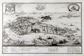 | Details | de Fer, Nicolas | 1705 |
| Antique Engraved Birds-eye View of Venice, Italy |
|
de Fer, Nicolas |
|
| 1705 |
| LOC:7 |
| $500.00 | de-Fer--Nicolas | Antique-Engraved-Birds-eye-View-of-Venice--Italy | Antique birds-eye view of Venice, Italy with the Grand Canal, Giudecca, the Venetian Arsenal, and St. Mark's Square as they existed around 1700. This attractive, detailed, copper-plate engraved view includes the outlying islands of Murano, Mazzorbo, Torcello, San Michelle, and others. Numerous churches are identified by name and a legend at bottom is keyed to the six chief Venetian neighborhoods or sestieri. Ten important locations are identified including the columns at St. Mark's square, erected in the 13th century; two prisons; the Ducal Palace; and the customs house.
<br></br>
This antique view was produced by the well known French geographer and cartographer, Nicolas de Fer (1646 - 1720). De Fer was a prolific producer of maps and prints who among other honors, was appointed as official geographer to the Spanish King in 1702. Published in de Fer's atlas: "L'Atlas Curieux, ou Le monde réprésenté dans des cartes générales et particulières du ciel et de la terre… et orné par des plans et descriptions des villes capitales et principales, ...". |
| 867 |  | Details | de Fer, Nicolas | 1705 |
| Birds-eye view of Constantinople or Istanbul, Turkey |
|
de Fer, Nicolas |
|
| 1705 |
| LOC:7 |
| $545.00 | de-Fer--Nicolas | Birds-eye-view-of-Constantinople-or-Istanbul--Turkey | Very detailed and attractive antique engraving of Constantinople or Istanbul, Turkey published from Paris in 1705. Minute detail of all the numerous towers, lighthouses, minarets and mosques that filled the city in the early 18th century.
<br></br>
Two settlements outside the well-fortified walls are noted: Galata, and on the Anatolian side of the Bosporus Strait- Scutari, which today is a municipality of Istanbul called Üsküdar. A few hundred meters off the coast of Scutari, on a small rocky islet is pictured the "Tour de Leander" or Maiden's Tower (Turkish: Kız Kulesi) , which over many centuries has served as watchtower, quarantine station, lighthouse, and defensive structure. Today the tower has been converted into a café and restaurant.
<br></br>
Other named features include the Tower of Belisarius ("Tour de Bellissaire"), le Serail, the Seven Towers ("Les 7 Tours"), le Solimanie, Constantine's Palace, les Magazines de Pera, and Calcedoine.
<br></br>
This antique view was produced by the well known French geographer and cartographer, Nicolas de Fer (1646 - 1720). De Fer was a prolific producer of maps and prints who among other honors, was appointed as official geographer to the Spanish King in 1702. From "L'Atlas Curieux, ou Le monde réprésenté dans des cartes générales et particulières du ciel et de la terre." |
| 1104 | 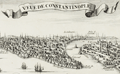 | Details | de Fer, Nicolas | 1705 |
| Veue de la ville et du port de Constantinople |
|
de Fer, Nicolas |
|
| 1705 |
| LOC:0 |
| $0.00 | de-Fer--Nicolas | Veue-de-la-ville-et-du-port-de-Constantinople | SOLD<br></br>
Very detailed and attractive antique engraving of Constantinople or Istanbul, Turkey published from Paris in 1705. Minute detail of all the numerous towers, lighthouses, minarets and mosques that filled the city in the early 18th century.
<br></br>
Two settlements outside the well-fortifed walls are noted: Galata, and on the Anatolian side of the Bosphorous Strait- Scutari, which today is a municipality of Istanbul called Üsküdar. A few hundred meters off the coast of Scutari, on a small rocky islet is pictured the "Tour de Leander" or Maiden's Tower (Turkish: Kız Kulesi) , which over many centuries has served as watchtower, quarrantine station, lighthouse, and defensive structure. Today the tower has been converted into a café and restaurant.
<br></br>
Other named features include the Tower of Belisarius ("Tour de Bellissaire"), le Serail, the Seven Towers ("Les 7 Tours"), le Solimanie, Constantine's Palace, les Magazines de Pera, and Calcedoine.
<br></br>
This antique view was produced by the well known French geographer and cartographer, Nicolas de Fer (1646 - 1720). De Fer was a prolific producer of maps and prints who among other honors, was appointed as official geographer to the Spanish King in 1702. Published in de Fer's atlas: "L'atlas curieux, ou Le monde réprésenté dans des cartes générales et particulières du ciel et de la terre… et orné par des plans et descriptions des villes capitales et principales ...". |
| 992 | 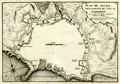 | Details | de Fer, Nicolas | 1715 |
| Old plan of Palma, Majorca or Mallorca, Spain |
|
de Fer, Nicolas |
|
| 1715 |
| LOC:4 |
| $495.00 | de-Fer--Nicolas | Old-plan-of-Palma--Majorca-or-Mallorca--Spain | Attractive, detailed antique birds-eye view or plan of Palma the capital of Mallorca / Majorca, now part of Spain. Features the walls, gates, roads, and numerous Vauban-style defenses that surrounded Palma / Palme in the early 18th century. Majorca is the largest of Spain's Balearic Islands, located south of Barcelona in the Mediterranean Sea. Will frame and display nicely.
<br></br>
Numerous defensive bastions are numbered and the key roads leading into the city are named including:
Chemin de Plumayor, Chemin de Manacor, Chemin d'Inca, Chemin Banola, and Chemin de Soller. City gates are also named including: Puerta de Jesus, Puerta Santa Catarina, Puerta de Campo, Puerta St. Antoine, Puerta Pintada, and Porte au Mole, leading to a jetty in the harbor. Additional defensive works under construction are shown with dotted lines. At the northeast, a single stream leading into the city walls is shown connected to a short aqueduct.
<br></br>
This antique copperplate-engraved map was produced toward the end of the 17th century by the well known French geographer and cartographer, Nicolas de Fer (1646 - 1720). De Fer was a prolific producer of maps and prints who among other honors, was appointed as official geographer to the Spansh King in 1702.Dated within at 1715. From de Fer's "Forces de l'Europe ou Introduction a la Fortification".
<br></br>
Plate No. 69. |
| 1297 | 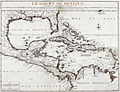 | Details | de Fer, Nicolas | 1717 |
| Scarce antique map of Gulf of Mexico and Caribbean |
|
de Fer, Nicolas |
|
| 1717 |
| LOC:51 |
| $1,950.00 | de-Fer--Nicolas | Scarce-antique-map-of-Gulf-of-Mexico-and-Caribbean | Very interesting and scarce Nicolas de Fer map (1717) of the Gulf Coast of the United States, the Caribbean, Central America, and northern South America. Pleasing appearance with original outline handcoloring. This 300 year-old copper-plate engraved map is full of local place names, historical notes and observations about native American tribes. For example:
<div class="indenttextblock">
<ul style="list-style-type: circle;">
<li>Near the Mississippi River mouth- "Embouchure du Mississippi decouverte in 1685 par M. de la Salle" and a location "Pointe de Mardi Gras".</li>
<li>About the fishing skills of American indians near the Georgia Sea Islands: "Isles de Mosquites Peuples plus adroit por peche de tout l' Amerique".</li>
<li>De Fer locates several native American tribes including "les Natchez", "Village de Apalaches" and "Village de la Mobile". </li>
<li>Locates La Salle's fort ('Fort de Francois') on Matagorda Bay, Texas ('Baye de St. Louis et de St. Bernard').</li>
</ul>
</div>
De Fer's seminal map of the Caribbean "Le Golfe de Mexique..." is a fine adaptation of Guillaume Delisle's 1701 "Carte des environs du Missisipi". The map shows a well-formed Mississippi Delta and Gulf Coast and locates La Salle's fort ('Fort de Francois') on Matagorda Bay, Texas ('Baye de St. Louis et de St. Bernard').
<br></br>
De Fer's "Le Golfe de Mexique" displays Florida correctly as a peninsula rather than as an archipelago, as first depicted by Thomas Nairne in 1711. The 300 year old map is based upon information obtained from the War of Spanish Succession and other contemporary sources. The map is considerably rarer than De L'Isle's contemporary map and more focused on the Caribbean and Gulf Coast regions. |
| 592 | 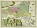 | Details | de Fer, Nicolas | 1730 |
| Le Roussillon |
|
de Fer, Nicolas |
|
| 1730 |
| LOC:0 |
| $1,100.00 | de-Fer--Nicolas | Le-Roussillon | Beautiful, old, antique map of the French historical county of Roussillion and the southern French Mediterranean coastline ca. 1730 . Today the area comprises the French department of Pyrenees-Orientales. With 7 inset plans of towns surrounded by walled Vauban-style fortifications: Perpignan; Ville-Franche; Mont-Louis; Belle-Garde; Collioure; Puicerda; Roses. Coverage includes northern Catalonia (Catalunya ). Interestingly an inset shows the town of Roses, Spain as part of Roussillon.
<br></br>
A compass rose and numerous galleys and square-rigged ships at battle fill the Mediterranean. Extremely colorful, decorative and interesting.
<br></br>
This scarce antique map of Roussillon was produced ca. 1727 by Nicholas de Fer, Geographer to Louis XIV. Published from Paris by G. Danet "sur le Pont N. Dame sur la Sphere Royale". Verso blank. |