| | Thumbnail | | Creator | Date | Title / Author / Date / Location | Price | | | Description |
| 269 | 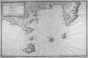 | Details | Ayrouard, Jacques | 1746 |
| Plan du Golfe de Naples |
|
Ayrouard, Jacques |
|
| 1746 |
| LOC:0 |
| $0.00 | Ayrouard--Jacques | Plan-du-Golfe-de-Naples | SOLD<br></br> Please search our site for "Ayrouard" for a similar engraving with beautiful hand-color..
<br></br>
Lovely antique nautical chart by Jacques Ayrouard (Marseilles ca. 1746) from a scarce nautical atlas: "Recueil de Plusiers Plans des Ports et Rades et de Quelque Cartes Particulieres de la Mer Mediterranee". |
| 3585 | 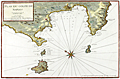 | Details | Ayrouard, Jacques | 1746 |
| Antique chart of the Gulf of Naples by Ayrouard |
|
Ayrouard, Jacques |
|
| 1746 |
| LOC:88 |
| $0.00 | Ayrouard--Jacques | Antique-chart-of-the-Gulf-of-Naples-by-Ayrouard | SOLD<br><br>
Beautifully colored antique nautical chart of the Bay of Naples, Italy by Jacques Ayrouard (Marseilles ca. 1746). From Ayrouard's scarce nautical atlas: "Recueil de Plusiers Plans des Ports et Rades et de Quelque Cartes Particulieres de la Mer Mediterranee".
<BR> </BR>
This fine small-scale copperplate-engraved chart covers the entire Bay of Naples, including Mount Vesuvius, Vigo, Sorrento, and the islands of Ischia (Iscle), Procida (Procita), and Capri (Cabrita). Numerous windmills, guard towers, and other structures are noted. Shows much of Italy's justly famous Amalfi Coast as far to the north as the vicinity of Positano and Praiano.
<BR> </BR>
Mount Vesuvius is shown erupting. According to one source, relatively severe eruptions of Vesuvius occurred in 1660, 1682, 1694, 1698, 1707, 1737. The 1737 event brought disaster to the town of Torre del Greco.
<BR> </BR>
Little information exists on Ayrouard's background but like <a style="color:#9BAFCB" rel="nofollow" href= "/MichelotBremondBackground.aspx">Henry Michelot</a>, Ayrouard was a pilot of the French royal galley, the Reale, based in Marseille. However, Ayrouard's port plans and charts are very different from Michelot's earlier works. The much larger size (17"x11") and the extensively shaded topography are distinctive characteristics of Ayrouard's plans.
<BR> </BR>
Large compass rose with fleur-de-lis. Plate 35. With the royal privilege. |
| 3586 | 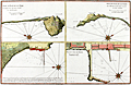 | Details | Ayrouard, Jacques | 1746 |
| Scarce Port Plan details near the Bay of Naples |
|
Ayrouard, Jacques |
|
| 1746 |
| LOC:88 |
| $475.00 | Ayrouard--Jacques | Scarce-Port-Plan-details-near-the-Bay-of-Naples | Beautifully colored antique detailed nautical plans of four areas near the Bay of Naples, Italy by Jacques Ayrouard (Marseilles ca. 1746). From Ayrouard's scarce nautical atlas: "Recueil de Plusiers Plans des Ports et Rades et de Quelque Cartes Particulieres de la Mer Mediterranee". Includes the breakwater/wharf in Naples; the port of Pozzuoli; and two views of the "Cote Romaine" or Roman Coast south of Terracina.
<BR> </BR>
Little information exists on Ayrouard's background but like <a style="color:#9BAFCB" rel="nofollow" href= "/MichelotBremondBackground.aspx">Henry Michelot</a>, Ayrouard was a pilot of the French royal galley, the Reale, based in Marseille. However, Ayrouard's port plans and charts are very different from Michelot's earlier works. The much larger size (17"x11") and the extensively shaded topography are distinctive characteristics of Ayrouard's plans.
<BR> </BR>
Plate 34. With the royal privilege. |
| 182 | 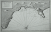 | Details | Ayrouard, Jacques | 1746 |
| Plan de la Baye d'Alicant |
|
Ayrouard, Jacques |
|
| 1746 |
| LOC:8 |
| $375.00 | Ayrouard--Jacques | Plan-de-la-Baye-d-Alicant | This antique, black and white harbor chart /port plan of Alicante Bay, Spain is by Jacques Ayrouard (Marseilles ca. 1732- 1746) from a scarce atlas titled: "Recueil de Plusiers Plans des Ports et Rades et de Quelque Cartes Particulieres de la Mer Méditerranée". Coverage extends eastward from Cap St. Paul to past Cap de la Houerta. Engraved by Louis Corne. Plate 67. <BR> </BR>
Little information exists on Ayrouard's background but like Henry Michelot before him, Ayrouard was a pilot of the French royal galley, the Reale, based in Marseille. However, Ayrouard's port plans are very different from Michelot's earlier works. The much larger size (18"x11") and extensively shaded topography in this plan are distinctive characteristics of Ayrouard's nautical plans. <BR> </BR> |
| 1378 | 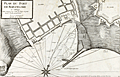 | Details | Ayrouard, Jacques | 1746 |
| Scarce antique port plan of Barcelona, Spain |
|
Ayrouard, Jacques |
|
| 1746 |
| LOC:8 |
| $700.00 | Ayrouard--Jacques | Scarce-antique-port-plan-of-Barcelona--Spain | Scarce antique French port plan / chart for the town of Barcelona, Spain on Spain's Mediterranean coast. This expertly designed and robustly executed antique chart is by Jacques Ayrouard (Marseilles ca. 1732- 1746) from a scarce atlas titled: "Recueil de Plusiers Plans des Ports et Rades et de Quelque Cartes Particulieres de la Mer Mediterranee". In a style that reflects Ayrouard's military and engineering background.
<br></br>
In the attribution Ayrouard is described as "Pilote Real" or pilot of la Reale, the flagship of the French galley corps with a total complement of about 550 including 360 oarsmen and 100 soldiers. In their <i>Dictionnaire de la Marine</i> from 1702 Covens and Mortier explain: <div class="indenttextblock">"(Réale) is the name of the main galley of an independent kingdom, not of a tributary kingdom annexed to a greater one. The Réale, in France, is reserved for the general of the galleys and flies the royal ensign which distinguishes it from the others. This ensign is square in shape and red in colour, with golden fleurs-de-lys." <a href="http://www.ulmo.net/bateaux/reale/dico02.jpg" target="_blank"> (Internet)</a> </div>
Ayrouard was likely one of the last such pilots as the French Corps des Galeres was disbanded in 1748 and incorporated into the regular French sailing navy. |
| 6774 | 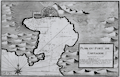 | Details | Ayrouard, Jacques | 1746 |
| Plan du Port de Cartagene |
|
Ayrouard, Jacques |
|
| 1746 |
| LOC:8 |
| $375.00 | Ayrouard--Jacques | Plan-du-Port-de-Cartagene | Fine nautical chart or plan of the town and harbor of Cartagena, Spain by Jacques Ayrouard (Marseilles ca. 1732- 1746). Original copperplate engraving shows the town of Cartagena surrounded by defensive walls, and unusually for 18th century charts/plans shows the adjacent topography in great detail. Noted features include l'Hermitage", "le Chateau", "pointe du fort", and "pointe galere" near a "chapelle".
<br></br>
<div id="0" align="center">
<a title=""></a>
<img id="6774" src="/ZoomifyImages/SC_6774/SC_6774_detail_1.jpg" alt="Plan du Port de Cartagene a nautical port plan for Cartagena, Spain by Jacques Ayrouard 1746." width="340"/> <br><br> <font size="-2">View of Cartagena, Spain by Ayrouard, 1746.</font>
</div><br>
Sourced from Ayrouard's scarce sea atlas: "Recueil de Plusiers Plans des Ports et Rades et de Quelque Cartes Particulieres de la Mer Méditerranée." Beautifully engraved by Louis Corne.
<br></br>
Ayrouard was a pilot of the French royal galley, the Reale, based in Marseille, France. The much larger size (18"x11") and extensively shaded topography in this plan are distinctive characteristics of Ayrouard's nautical port plans. Plate 68. <BR> </BR> |
| 183 | 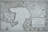 | Details | Ayrouard, Jacques | 1746 |
| Plan de la Port de Cartagene |
|
Ayrouard, Jacques |
|
| 1746 |
| LOC:8 |
| $450.00 | Ayrouard--Jacques | Plan-de-la-Port-de-Cartagene | This antique nautical chart or plan of the town and harbor of Cartagena, Spain by Jacques Ayrouard (Marseilles ca. 1732- 1746) is sourced from a scarce sea atlas titled: "Recueil de Plusiers Plans des Ports et Rades et de Quelque Cartes Particulieres de la Mer Méditerranée". Beautifully engraved by Louis Corne this copperplate engraving shows the town of Cartagena surrounded by defensive walls, and unusually for 18th century charts/plans shows the adjacent topography in great detail.
<br></br>
Like <a rel="nofollow" href= "/MichelotBremondBackground.aspx">Henry Michelot</a> before him, Ayrouard was a pilot of the French royal galley, the Reale, based in Marseille. However, Ayrouard's port plans are very different from Michelot's earlier works. The much larger size (18"x11") and extensively shaded topography in this plan are distinctive characteristics of Ayrouard's nautical plans. Plate 68. <BR> </BR> |
| 62 | 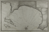 | Details | Ayrouard, Jacques | 1746 |
| Plan de La Baye du Gourien et des Isles St. Marguerite |
|
Ayrouard, Jacques |
|
| 1746 |
| LOC:8 |
| $390.00 | Ayrouard--Jacques | Plan-de-La-Baye-du-Gourien-et-des-Isles-St--Marguerite | Scarce, antique nautical harbor plan / chart of the village of Cane' (Cannes) France on the French Riviera with the offshore Lerins Islands. On the largest of these islands, Ile Sainte-Marguerite, the Man in the Iron Mask was held prisoner during 1687-1698. This antique chart of the area around Cannes is by Jacques Ayrouard (Marseilles ca. 1732- 1746) from a scarce atlas titled: "Recueil de Plusiers Plans des Ports et Rades et de Quelque Cartes Particulieres de la Mer Méditerranée". <BR> </BR>
Interior areas shown with little structural detail, but do contain significant shading and hachuring to convey elevation details. Little information exists on Ayrouard's background but like Henry Michelot before him, Ayrouard was a pilot of the French royal galley, the Reale, based in Marseille. However, Ayrouard's port plans are very different from Michelot's earlier works. The much larger size (18"x11") and extensively shaded topography are distinctive characteristics of Ayrouard's charts. <BR> </BR>
On chain-laid paper. Large compass rose with fleur-de-lis. Plate 13. |
| 63 | 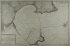 | Details | Ayrouard, Jacques | 1746 |
| Plan du Port d'Antibe |
|
Ayrouard, Jacques |
|
| 1746 |
| LOC:8 |
| $450.00 | Ayrouard--Jacques | Plan-du-Port-d-Antibe | Antique port / harbor plan of the northwest portion of the fortress at Antibe, France and the harbor including Fort Quare opposite to the north. Much detail about the Antibes breakwater and mole. Small inset in upper right containing a profile of the mole and fortifications as seen from the sea. This chart is by Jacques Ayrouard (Marseilles ca. 1732- 1746) from a scarce atlas titled: "Recueil de Plusiers Plans des Ports et Rades et de Quelque Cartes Particulieres de la Mer Méditerranée". <BR> </BR>
Little information exists on Ayrouard's background but like <a rel="nofollow" href= "/MichelotBremondBackground.aspx">Henry Michelot</a>, Ayrouard was a pilot of the French royal galley, the Reale, based in Marseille, France. However, Ayrouard's port plans and rare sea charts are very different from Michelot's earlier works. The much larger size (18"x11") and extensively shaded topography seen in this plan of Antibe are distinctive characteristics of Ayrouard's plans. Engraved by Louis Corne. Plate 15. <BR> </BR> |
| 6777 | 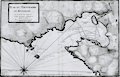 | Details | Ayrouard, Jacques | 1746 |
| Plan du Portvendre en Rousillon |
|
Ayrouard, Jacques |
|
| 1746 |
| LOC:8 |
| $375.00 | Ayrouard--Jacques | Plan-du-Portvendre-en-Rousillon | Fine original hydrographic port and harbor chart for Portvendre (Port-Vendres), France by Jacques Ayrouard (Marseilles ca. 1732- 1746). This antique copperplate engraving shows the town of Port-Vendres as it was in 1733 with the adjacent topography in great detail. Noted features include the Devil's Tower- "Tour de Diable", Fort de la Mauresque or "le Fort et le Fanal", "la Redoutte", the "Cote qui va a Cadequie" and "Cote qui va a Colioure., "le bourg", two other towers- "la masane" and "St. Elme", and the "maison du gouvernment". North is oriented to the bottom of the chart.
<br></br>
Ayrouard makes extensive use of depth soundings and variegated stippling for rough depth contour intervals and has laid down sight bearing lines from the above towers to other fixed objects to help mariners navigate the challenging entrance to Port-Vendres.
<br></br>
<div id="0" align="center">
<a title=""></a>
<img id="6777" src="/ZoomifyImages/SC_6777/SC_6777_detail_1.jpg" alt="Plan du Portvendre en Rousillon. A hydrographic port plan for Port-Vendres, Frances by Jacques Ayrouard. 1746." width="340"/> <br><br> <font size="-2">View of Port-Vendres, Frances by Ayrouard, 1746.</font>
</div><br>
Sourced from Ayrouard's scarce sea atlas: "Recueil de Plusiers Plans des Ports et Rades et de Quelque Cartes Particulieres de la Mer Méditerranée." Beautifully engraved by Louis Corne.
<br></br>
Ayrouard was a pilot of the French royal galley, the Reale, based in Marseille, France. The much larger size (18"x11") and extensively shaded topography in this plan are distinctive characteristics of Ayrouard's nautical port plans. Plate 68. <BR> </BR> |
| 543 | 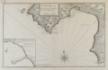 | Details | Ayrouard, Jacques | 1746 |
| Plan de la Baye et Port de Mayorque (Palma Majorca or Mallorca) |
|
Ayrouard, Jacques |
|
| 1746 |
| LOC:8 |
| $600.00 | Ayrouard--Jacques | Plan-de-la-Baye-et-Port-de-Mayorque-(Palma-Majorca-or-Mallorca) | Antique original engraved chart of the northwest portion of the island of Mallorca, Spain, the largest of the Balearic islands in the Mediterranean sea. Includes the capital city, Palma surrounded by a wall, and the Bay of Palma. Coverage extends from the "Cote de Solery" and Sa Dragonera (with two watchtowers shown) past the Bay of Palma to "Cap Blanc". A detailed inset includes the area at the harbor in Palma, "la mole", a jetty or breakwater where according to Ayrouard there was room to moor 5 galleys stern-first, as is still the custom in the Mediterranean: "en grande point, on peut y placer 5 galeres la poupe au mole en quatres amarres." <br><br/>
This rare chart by Jacques Ayrouard (Marseilles ca. 1730) comes from a scarce nautical atlas: "Recueil de Plusiers Plans des Ports et Rades et de Quelque Cartes Particulieres de la Mer Mediterranee". <br><br/>
Little information exists on Ayrouard's background but like <a style="color:#9BAFCB" rel="nofollow" href= "/MichelotBremondBackground.aspx">Henry Michelot </a> two decades earlier, Ayrouard was a pilot of the French royal galley, the Reale, based in Marseille. Ayrouard's port plans and charts are very different from Michelot's earlier works; the much larger size (17"x11") and the extensively shaded topography enable the viewer to easily recognize Ayrouard's plans. Large compass rose with fleur-de-lis. Plate 70 but manuscript notation at upper left reads "No. 69". |
| 1181 | 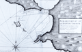 | Details | Ayrouard, Jacques | 1746 |
| Antique plan of the Bay of Taranto, Italy |
|
Ayrouard, Jacques |
|
| 1746 |
| LOC:8 |
| $375.00 | Ayrouard--Jacques | Antique-plan-of-the-Bay-of-Taranto--Italy | Distinctive antique engraved French port plan / chart ca. 1746 for the bay and walled village of Taranto, Italy a coastal city in Apulia. Today, Taranto is the capital of the Province of Taranto and is an important commercial port as well as the main Italian naval base and claims a population of over 200,000 persons.
<br></br>
The antique chart is by Jacques Ayrouard (Marseilles ca. 1732- 1746) from a scarce atlas titled: "Recueil de Plusiers Plans des Ports et Rades et de Quelque Cartes Particulieres de la Mer Mediterranee". Plate 37.
<br></br>
Ayrouard identifies a few key landmarks including several offshore: La Pizolle, Isle Pisco, Isle de St. George, and two channels into the bay. On land only a few landmarks are noted including guard towers, the port; the village of Taranto ("Tarante") connected to the mainland by two bridges; and the Pointe de Victo where today is found the area of San Vito.
<br></br>
In the attribution Ayrouard is described as "Pilot Real" or pilot of la Reale, the flagship of the French galley corps with a total complement of about 550 including 360 oarsmen and 100 soldiers. In their <i>Dictionnaire de la Marine</i> from 1702 Covens and Mortier explain: <div class="indenttextblock">"(Réale) is the name of the main galley of an independent kingdom, not of a tributary kingdom annexed to a greater one. The Réale, in France, is reserved for the general of the galleys and flies the royal ensign which distinguishes it from the others. This ensign is square in shape and red in colour, with golden fleurs-de-lys." <a href="http://www.ulmo.net/bateaux/reale/dico02.jpg" target="_blank"> (Internet)</a> </div>
Ayrouard was likely one of the last galley pilots as the French galley corps was disbanded in 1748 and incorporated into the regular French sailing navy. |
| 907 | 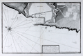 | Details | Ayrouard, Jacques | 1746 |
| Antique plan of the port of Livorno, Italy |
|
Ayrouard, Jacques |
|
| 1746 |
| LOC:8 |
| $525.00 | Ayrouard--Jacques | Antique-plan-of-the-port-of-Livorno--Italy | Antique French port plan / chart for the town of Livorno, Italy located on the western coast of the Tuscany region.
The antique chart is by Jacques Ayrouard (Marseilles ca. 1732- 1746) from a scarce atlas titled: "Recueil de Plusiers Plans des Ports et Rades et de Quelque Cartes Particulieres de la Mer Mediterranee".
<br></br>
Ayrouard identifies a few key landmarks including several offshore: a "fanal" or lighthouse and another the "Tour de la Marsoque". On land only a few landmarks are noted including "Les 4 gigantes" a reference to the Four Moors statue (the engraver includes a tiny icon-like representation of the statue) next to "la darce" or the old port for Livorno; a church- St. Francois; and of course the walled town of Livorno ("Livourne") itself.
<br></br>
In the attribution Ayrouard is described as "Pilot Real" or pilot of la Reale, the flagship of the French galley corps with a total complement of about 550 including 360 oarsmen and 100 soldiers. In their <i>Dictionnaire de la Marine</i> from 1702 Covens and Mortier explain: <div class="indenttextblock">"(Réale) is the name of the main galley of an independent kingdom, not of a tributary kingdom annexed to a greater one. The Réale, in France, is reserved for the general of the galleys and flies the royal ensign which distinguishes it from the others. This ensign is square in shape and red in colour, with golden fleurs-de-lys." <a href="http://www.ulmo.net/bateaux/reale/dico02.jpg" target="_blank"> (Internet)</a> </div>
Ayrouard was likely one of the last such pilots as the French Corps des Galeres was disbanded in 1748 and incorporated into the regular French sailing navy. |
| 908 |  | Details | Ayrouard, Jacques | 1746 |
| Antique plan of the port of Civitavecchia, Italy |
|
Ayrouard, Jacques |
|
| 1746 |
| LOC:8 |
| $525.00 | Ayrouard--Jacques | Antique-plan-of-the-port-of-Civitavecchia--Italy | Plan of Civitavecchia, Italy also referred to as the "port of Rome", as it lies on the Tyrrhenian Sea, about 50 miles south of Rome. The antique chart is by Jacques Ayrouard (Marseilles ca. 1732- 1746) from a scarce atlas titled: "Recueil de Plusiers Plans des Ports et Rades et de Quelque Cartes Particulieres de la Mer Mediterranee". Identifies only a few features by name including "la Darce" or the old port, and significantly "les Chantiers des Galeres" or the boatyard where galleys were constructed and repaired.
<br></br>
In the attribution Ayrouard is described as "Pilot Real" or pilot of la Reale, the flagship of the French galley corps with a total complement of about 550 including 360 oarsmen and 100 soldiers. In their <i>Dictionnaire de la Marine</i> from 1702 Covens and Mortier explain: <div class="indenttextblock">"(Réale) is the name of the main galley of an independent kingdom, not of a tributary kingdom annexed to a greater one. The Réale, in France, is reserved for the general of the galleys and flies the royal ensign which distinguishes it from the others. This ensign is square in shape and red in colour, with golden fleurs-de-lys." <a href="http://www.ulmo.net/bateaux/reale/dico02.jpg" target="_blank"> (Internet)</a> </div>
Ayrouard was likely one of the last such pilots as the French Corps des Galeres was disbanded in 1748 and incorporated into the regular French sailing navy.
<br></br>
Little information exists on Ayrouard's background but like Henry Michelot, Ayrouard was a pilot of the French royal galley, the Reale, based in Marseille, France. However, Ayrouard's port plans and rare sea charts are very different from Michelot's earlier works. The much larger size (18"x11") and extensively shaded topography seen in this plan of Antibe are distinctive characteristics of Ayrouard's plans. Engraved by Louis Corne. Published with the royal privilege. |
| 1328 | 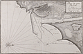 | Details | Ayrouard, Jacques | 1746 |
| Antique plan of the port of Cette, France (Sete) |
|
Ayrouard, Jacques |
|
| 1746 |
| LOC:8 |
| $600.00 | Ayrouard--Jacques | Antique-plan-of-the-port-of-Cette--France-(Sete) | Antique French Mediterranean port plan or chart for the town of <b>Sète, France</b> (Cette) in the southeast French region of Occitanie. This old port plan by Jacques Ayrouard (Marseilles ca. 1732- 1746) depicts the small port of Sète in 1733, likely on an earlier visit by Ayrouard. Of particular interest is that Sète is and was the Mediterranean terminus for the Canal Royal de Languedoc ( now the <b>Canal du Midi</b> ), opened in 1681. Shows the protective outer môle or jetty with a walkway and an inner jetty of rock. Wharves line docks where offshore sailing vessels would have had their cargos unloaded and trans-shipped through the canal in smaller shallow-draft barges. In the early 18th century French galleys may have traveled through the canal between their base in Marseilles and Bordeaux, St. Malo or Dunkirk. (Source: Chatelain, Henry. "Carte Generalle du Gouvernement Militaire de France")
<br></br>
The antique chart was published from Marseilles, France in a scarce atlas titled: "Recueil de Plusiers Plans des Ports et Rades et de Quelque Cartes Particulieres de la Mer Mediterranee".
<br></br>
In the attribution Ayrouard is described as "Pilot Real" or pilot of la Reale, the flagship of the French galley corps with a total complement of about 550 including 360 oarsmen and 100 soldiers. In their <i>Dictionnaire de la Marine</i> from 1702 Covens and Mortier explain: <div class="indenttextblock">"(Réale) is the name of the main galley of an independent kingdom, not of a tributary kingdom annexed to a greater one. The Réale, in France, is reserved for the general of the galleys and flies the royal ensign which distinguishes it from the others. This ensign is square in shape and red in colour, with golden fleurs-de-lys." <a href="http://www.ulmo.net/bateaux/reale/dico02.jpg" target="_blank"> (Internet)</a> </div> |
| 1473 |  | Details | Ayrouard, Jacques | 1746 |
| Scarce antique port plan of Port-de-Bouc, France |
|
Ayrouard, Jacques |
|
| 1746 |
| LOC:8 |
| $300.00 | Ayrouard--Jacques | Scarce-antique-port-plan-of-Port-de-Bouc--France | Scarce antique French port chart for the town of Port-de-Bouc, France made by Jacques Ayrouard, at Marseilles, in 1746. No. 35.
<br></br>
In the attribution at bottom, Ayrouard is described as "Pilote Real", or pilot of la Reale, the flagship of the French galley corps with a total complement of about 550 including 360 oarsmen and 100 soldiers. In their <i>Dictionnaire de la Marine</i> from 1702 Covens and Mortier explain: <div class="indenttextblock">"(Réale) is the name of the main galley of an independent kingdom, not of a tributary kingdom annexed to a greater one. The Réale, in France, is reserved for the general of the galleys and flies the royal ensign which distinguishes it from the others. This ensign is square in shape and red in colour, with golden fleurs-de-lys." <a href="http://www.ulmo.net/bateaux/reale/dico02.jpg" target="_blank"> (Internet)</a> </div>
Ayrouard was likely one of the last such pilots as the French Corps des Galeres was disbanded in 1748 and incorporated into the regular French sailing navy. |
| 4973 | 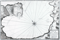 | Details | Ayrouard, Jacques | 1746 |
| Antique plan of Portoferraio Porto Ferraro Italy |
|
Ayrouard, Jacques |
|
| 1746 |
| LOC:0 |
| $425.00 | Ayrouard--Jacques | Antique-plan-of-Portoferraio-Porto-Ferraro-Italy | Fine copper-plate engraved 1746 antique port/harbor plan or chart of Porto Ferraro (Portoferraio), Italy by Jacques Ayrouard. Portoferraio is the largest city on the island of Elba, located in the Tyrrhenian Sea about 30 miles east of Corsica.
<br></br>
In the chart's attribution Ayrouard is described as "Pilot Real" or pilot of la Reale, the flagship of the French galley corps with a total complement of about 550 including 360 oarsmen and 100 soldiers. In their <i>Dictionnaire de la Marine</i> from 1702 Covens and Mortier explain: <div class="indenttextblock">"(Réale) is the name of the main galley of an independent kingdom, not of a tributary kingdom annexed to a greater one. The Réale, in France, is reserved for the general of the galleys and flies the royal ensign which distinguishes it from the others. This ensign is square in shape and red in colour, with golden fleurs-de-lys." <a href="http://www.ulmo.net/bateaux/reale/dico02.jpg" target="_blank"> (Internet)</a> </div>
Ayrouard was likely one of the last such pilots as the French Corps des Galeres was disbanded in 1748 and incorporated into the regular French sailing navy. Engraved by Louis Corne. |
| 5191 | 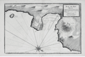 | Details | Ayrouard, Jacques | 1746 |
| Plan du Port Hercule Porto Ercole Tuscany |
|
Ayrouard, Jacques |
|
| 1746 |
| LOC:9 |
| $450.00 | Ayrouard--Jacques | Plan-du-Port-Hercule-Porto-Ercole-Tuscany | Original antique nautical chart or plan of the town and harbor of Port Hercule (Porto Ercole), Italy by Jacques Ayrouard (Marseilles ca. 1732- 1746). The plan is from Ayrouard's scarce sea atlas titled: "Recueil de Plusiers Plans des Ports et Rades et de Quelque Cartes Particulieres de la Mer Méditerranée". This engraved plan is of the old port at Porto Ercole which is located on the eastern side of the Monte Argentario promontory in the province of Grosetto, in the Tuscany region.
<br></br>
Like Henry Michelot, Jacques Ayrouard was a pilot of the French royal galley, the Reale, based in Marseille. However, Ayrouard's port plans are very different from Michelot's earlier works. The much larger size (18"x11") and extensively shaded topography in this plan are distinctive characteristics of Ayrouard's nautical plans. Plate 29. <br> </br> |